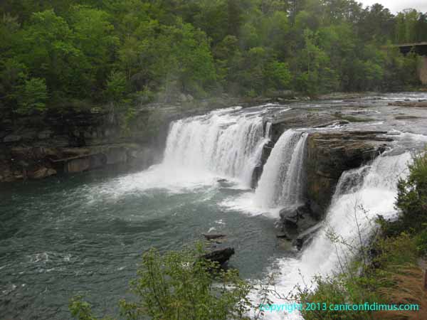
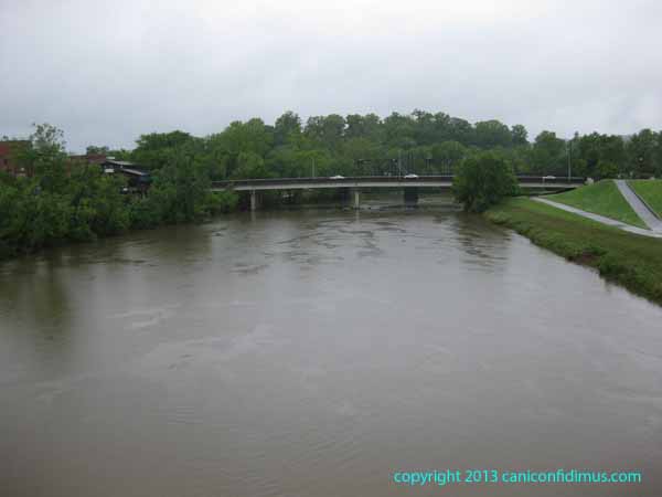
Last Friday on my way back to Rome from Huntsville, I stopped at the Little River Falls overlook to see what had happened to the flow since I saw it three days earlier. The river was down, but not very obviously. Here is the picture from a week ago last Tuesday (April 30) and from last Friday (May 3). You can see some differences. More rock is visible to the left in the second figure, but in general they look pretty similar.
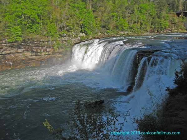
Little River Falls, Tuesday, April 30
Little River, May 3, 2013
After I got home, Leah and I went into town to eat. We stopped to get a picture of the Oostanaula River. This is a picture of the river Friday afternoon looking downstream from a pedestrian bridge towards the Second Avenue bridge.
Oostanaula River, May 3
Just downstream from the highway bridge there is an old, abandoned railroad bridge and just downstream from that, the Oostanaula flows into the Etowah River to form the Coosa River. Downtown Rome is to the left in this shot; Broad Street crosses the Etowah just up from the confluence of the two rivers. If you boated down the Coosa into Weiss Lake (watch out for the old Mayo’s Lock and Dam, because you have to portage around that), you could find the mouth of the Little River.
The Oostanaula was muddy, but the color was closer to a murky olive than to the red clay it sometimes shows immediately after heavy rain. The Little River was pretty much clear in both of the shots I took.
When I stopped at the Little River on Friday, I met a National Park Service volunteer who had a clipboard with an interesting figure. The figure showed a week-long history of the water flow in the Little River where it empties into Weiss Lake, not very many miles downstream from the waterfall.
Here is a figure I got from the USGS showing the period from just before the weekend of April 27-28, when we got a lot of rain. It includes last weekend, when we got some more rain. I put red diamonds on the chart showing the levels on Tuesday and Friday when I took the pictures. The Y-axis is on a logarithmic scale, which can be hard to read, so I added some additional numbers.
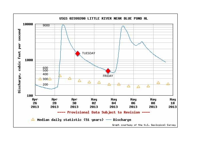
Streamflow on the Little River
You can see that the level on Friday, about 450 cubic feet per second, was roughly half what it had been on the Tuesday before. A cubic foot is about 7.5 gallons, so 450 cubic feet per second is about 3375 gallons per second. An olympic pool is about 660,000 gallons according to Wikipedia, so it would take a little over three minutes to fill at that flow. That doesn’t really sound like that much.
The Park Service volunteer showed me a picture of the falls from a few years ago when the flow was about twice the maximum of the April 27-28 weekend, or over 20,000 cubic feet per second. The photo was impressive. He said the record high flow was about twice that number, which would be really impressive, and probably scary from the overlook.
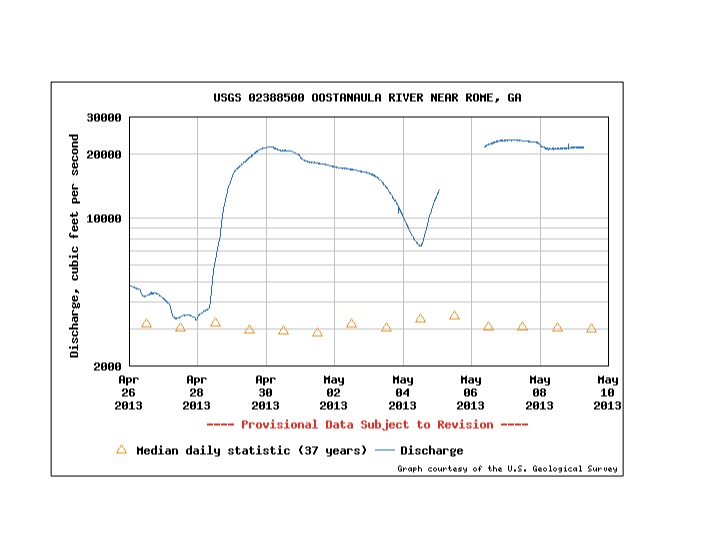
This is a figure showing streamflow for the Oostanuala River for the same period. I think the flow when I took the picture above was probably around 17,000 cubic feet per second.
Streamflow on the Oostanaula River
As I said in the earlier post, the Little River is a short river with a small watershed compared to the Oostanaula River, so it responds quickly to changes in the local rainfall. The Oostanaula itself is about 50 miles long, about the same as the Little River, but it is formed by two other rivers, the Conasauga, about 93 miles long, and the Coosawattee, about 50 miles. The Little River drains an area of about 200 square miles. The total Oostanaula basin is about 2150 square miles, more than 10 times larger. It’s no wonder it takes longer to respond. The tan colored triangles in the plots show the average stream flow for the two rivers. The Oostanaula is about 3000 cubic feet per second on average during this period, while the Little River is around 200 or 300 cubic feet per second, or about one-tenth as much. It seems reasonable that the stream flow is proportional to the area drained.
But there is another interesting difference between the two rivers. The Little River responds very quickly to rain, and then again when the rain stops. You can see how quickly the river flow drops during the week, when there was no rain. It started raining again late Friday and the river flow jumped up again pretty quickly. You can see a period when the rain stopped for a while over the weekend, and then started up again. Compare that to the flow of the Oostanaula. The Oostanaula began to drop after Friday, May 3, but slowly compared to the Little River. It increased again last weekend when it started to rain again. There is a segment with no data for some reason, but you can follow where the curve would be.
One of the interesting things about these figures is how this kind of behavior shows up in other physical systems. Most people have experience with cast-iron frying pans and also with aluminum foil. You know if you fry eggs in a cast-iron pan, the pan will stay hot for quite a while after you take it off the stove. And you probably also know that if you have a pan covered with aluminum foil in a hot oven, you can touch the aluminum foil almost immediately after you take it out of the oven. If you plotted the temperatures against time, the cast-iron pan would look like the Oostanaula, and the aluminum foil would look like the Little River. In my business, we would say the cast-iron pan is thermally massive, and the aluminum foil is thermally lightweight, or thermally responsive. I think it’s pretty cool stuff, but that’s just me.
I plan to keep my camera handy, and if we have some really heavy rain, I’m heading over to the Little River. I want to see just how scary it can get over there.